I had a two-day unplanned trip on January 28 and 29. It started as fancy tweeting between the Boss and my high school classmate Mr. Tan, who happened to be her workmate as well. Neither had a destination, they just wanted to get out. Like a quadrant with a very high “Y” but no “X.” So much energy, no place to channel.
I am lingering too much on my reluctance here. It’s because I did not really want to go out last weekend. I just rode a 160-km route Monday of that week and I wanted to stay in my bedroom in a fetal curl. No, the distance is not traumatic. It’s just that I’ve been out too often, too much for the past four months. I want to make myself feel that I have a home. Remind myself that I don’t have to stay out in the open all the time. Lol. So much for that.
Actually, it was a crazy fun weekend. We kicked off at Aguinid Falls, spent a great time at Pebbles Beach in Santander, then finished up at Inambakan Falls in Ginatilan. I have only posted about Aguinid Falls so far and this one wil lbe on Binalayan Falls, which I erroneously wrote as “Gimbalayan” at the previous post. I will post about Pebbles Beach later since it is the only place you can stay at when you are far down south. Then Inambakan Falls maybe tomorrow. I wanted to be more helpful lately after finding out that bots are not the only ones who visit my blog. Kudos to you if you are human, dear reader of this entry!
***
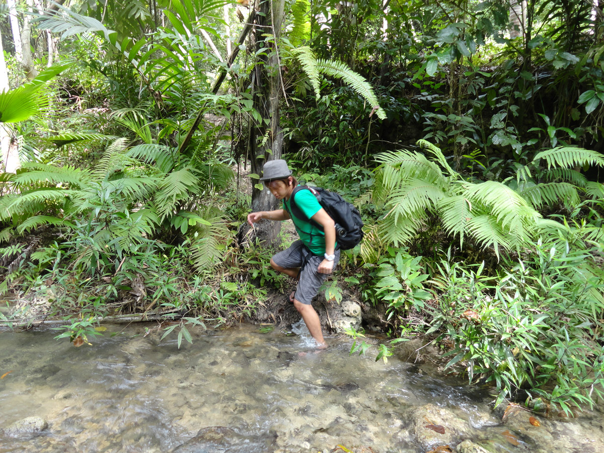
I’ll be anti-climactic and say that we did not find Binalayan Falls. We did not intend to go there in the first place. Mr. Tan and Chyrel Gomez just noticed that tarp on our way back to the town of Samboan. So we dropped by. If you are familiar with the south, the junction is along that perpetually under repair bridge in Samboan. It’s where your bus takes a turn around the bridge since that bridge have been under work since like the Big Bang. The water that flows under that bridge comes from Binalayan Falls.
The locals told us that Binalayan Falls is just “near.” Again, let us remind ourselves that descriptions which do not involve numbers are always relative. We forgot about that and we assumed that near is, well, actually near.
We thought it’s just a walk in the park from the high way. But there was no park, only lots of walk.
Actually, if you are familiar with the place, it would only take 15 minutes to reach the falls. Just walk upstream. You will have to criss-cross the river and even part from it for a while. Just don’t walk too far from it. You will eventually reach a point where all footpaths vanish. From there, you will have to walk in the river, Jesus Christ style. We did not proceed because there were leaves and twigs that block the river passage. We found out later from our friendly locals that the falls are just a short walk behind the river block (it’s not a road block!).
If you want to go out falls cruising down south, do check out Aguinid, Binalayan, Dau, and Inambakan falls. Make the most out of you 4-hour bus trip. Was our 20-minute of aimless wandering it? Yes, the river trek is worth getting lost for.
PS: There is nothing romantic or poetic about getting lost. I hate it, in fact. I just had a great night drinking-till-head-whirls, which I have not done for quite some time now since I have not been seeing my whore high school friend Michael. Fortunately, getting lost has no hang over or I'd put two people on top of my hate list.
Monday, January 30, 2012
Sunday, January 29, 2012
The Fabulous Mr. Tan: How to Get to Aguinid Falls in Samboan
Aguinid Falls is a cascade-type waterfall located in Barangay Tangbo, Samboan. There are a total of four falls that make up Aguinid. They are located widely apart so it takes a few minutes’ walk to get from one to the next. The junction to Aguinid Falls is located just near the barangay center so you will not have a tough time finding it. Tangbo, by the way, is a 10-minute tricycle ride from the town center of Samboan. I forgot to note how far it is from Santander but I guarantee you will not have a tough time finding it since it is quite popular among locals. Many locals bath at Aguinid Falls because it is easily accessible, being only a five-minute walk from the provincial road. I will let these photos describe the falls for me. Please check Google Earth if you do not know where Samboan is. Google Earth/Map is a very powerful tool and I even use it to find single-track trails. Thank Google for it.
This trip is totally unplanned on my part. I just logged on to Twitter one morning and James Tan (my high school classmate which I thought was my friend) and the Boss were tweeting about going to the south. The next morning, I was on a bus with two oppressive people (details about oppression omitted to for this post to suit general audience). I got too ahead with the bus ride there. It rained that morning and I was dripping and cold while waiting for my “friends” to show up on time. Luckily, the backpack that I borrowed from my five-year-old cousin had a rain cover. His father got it from the ukay-ukay. The brand is Genova and it was quite good. Amen to patience.
The rotunda at the town center of Samboan.
The Boss and the Fabulous Mr. Tan walking behind her.
On to the first fall.
The first mini-fall.
Second.
The third fall.
Chyrel Gomez and Mr. Tan minus the felt hat.
The fabulous Mr. Tan in his contemplative mood.
The fourth fall. It would be great to climb up and see what's out there.
Back to the third fall.
Going down the second waterfall.
***
There is another fall just a few minute's walk from the Aguinid Falls junction. It is called Gimbalayan Falls, located in Brgy. Bonbon. Bonbon is just right beside Tangbo. It's less than five minute's walk.
We tried going to the falls but we failed to find it. We walked up stream and just followed the tracks but at one point all the tracks vanished. We could not see beyond the river because it was covered with leaves and branches and twigs that cross over it. As we reached the highway, we found out from locals that the falls were just right behind it.
Labels:
waterfalls
Tuesday, January 24, 2012
Rise of the Jejemons: Carcar-Barili-Sibonga Vegetable Highway
Prologue
The Vegetable Highway is an asphalted road that connects the three towns of Carcar, Barili, and Sibonga. I starts at KM 46.5 and ends in Sibonga to the east and Dumanjug to the west. There is also a road the links it to Cebu's "Vegetable Basket," my favorite place in Cebu, Mantalongon, Dalaguete. (My next-to-my-room favorite place in Cebu, just to be precise.)
I
I jejevolved today (vb., to transform into a jejemon from a previous non-jejemon state). I was riding my bike listening to wRock when I started losing signal of the station. I changed the dial to the next station with a clear signal and 97.1 came up. As I would rather listen to anything that have a fatal boredom attack, I stuck with the station. First I was just listening to this song about drinking Margarita. It seemed that the tune and the instruments were more intoxicating than the margarita itself. It’s the my-heard-is-whirling-twirling kind of intoxicating, not the kind that gently puts you to sleep. A few more songs followed and soon enough I was singing to the tune of Lady Gaga and Taylor Swift remixes. I sang my larynx out even if the remixed tune got me offbeat every now and then (not that I’m ever “on beat”). A different person is slowly creeping into my being. Expect me to use a different set of alphabets soon and wear an obviously fake Monster Energy cap even if I am not into motocross and energy drinks.
II
Being a jejemon is not my only concern during that trip. Actually, I am at peace with the direction my being is taking. jejeje. I was really worried by the buses. If you have not been to the south, you have not seen reckless driving yet. I do not know how people who have utter disregard for safety are allowed to drive 12-tons of steel that can go way over 100kph. When these homicidal vehicles pass by, they create a slipstream that seems to pull you right underneath the bumper. Not to mention that they drive pretty close (by that I mean less than one meter) to cyclists. I always concede and create the necessary distance else I’ll be turned into random chunks of human anatomy.
III
Vegetable highway starts 6.5km from Carcar City. It’s right after the junction to Mainit Hot Spring. There’s a huge “Vegetable Highway” sign to your left so you will never have to worry about missing it. Just tilt your head in the most gymnastic way possible. The sign is way up in the sky. It must have been sponsored by the extra-terrestrial embassy.
From that junction is a two and a half hour bike ride to Samboan (photo shooting and self-timer moments included). You will never get lost as long you don’t take any of those turns you pass by. You will get to a “Y”-shaped junction when you already have to take your pick between Dumanjug and Samboan. It’s either left or right from there so no worries about getting lost. You don’t even have to ask the locals for direction.
I have always wanted to do this route and two weeks ago I got the chance to talk to a friend who’s been there already. He finished the longer and more punishing Dumanjug route in two hours, on a road bike. He’s a leg killer so I’m fine with my pace. I first planned to ride a bus to Carcar and start pedaling there. But I realized yesterday that I prefer to get run over than be on the bus when the accident happens. So it’s all-pedal mode today. I’m sleepy.
Everything turned out well except for two scary moments. Once I was enjoy the sweet tarmac-smooth downhill when my front tire ran over a stone. I going down too fast that I did not notice it (no pedestrians, no intersection, sheer downhill, you understand why). My front tire drew number 8s all over the road. I was lucky I regained control before any blog-entry-changing event happened.
Then another time was thing huge bump on the road. From the “Y” Junction at the Vegetable Highway you’ll be taking an unpaved barangay road. I was riding slow because my head was starting to hurt (refer to two entries before this) but I’ve lost my patience so I’ve let the brake levers go. Just when I was starting to accelerate I’ve hit a bump that nearly ripped my wrist off. Metaphorically speaking, of course.
Here’s a post-script to disaster. On my way home, I “sort-of” ran into a taxi’s rear bumper. It happened near the flyover at Wireless, Mandaue. The driver suddenly stopped to make a u-turn and I was too close to avoid contact. Luckily, my brakes functioned according to purpose. My rear tire got off the ground for a couple of feet, the front tire smacked the bumper, and nothing else happened. My fault, I did not keep my distance. I started to get my second wind at Mabolo and I was pedaling at a pace inappropriate for busy traffic.
IV
No matter how ridiculous jejemons may be to some of us, we must not fail to see that they are imitating a certain fashion/social behavior/hyrieglyphic code because they want a sense of uniqueness and belongingness. They want to feel that they belong to a unique group that accepts them for what they want to be. So as long as jejemons don’t bite you, let them be. Don’t call them the J word either.
![]() |
As I went up, it felt that the hills were rising with me. (It's a natural phenomenon actually, nothing poetic there.) |
![]() |
Mr. Lion Head. |
![]() |
A giant pushed these twin mountains apart to look for his missing marble. |
![]() |
"Major sponsor." jejeje. I did not notice that until the uploading of this photo. |
![]() |
It's a goose-bump-stimulating descent from here to there. |
![]() |
Marker. My marker, I mean. |
![]() |
Alternating between ground and hanging plants allow the soil to "breathe" so it remains fertile. |
![]() |
An abandoned hut. "Shack" as them GI say in Vietnam War movies. |
![]() |
I left before sunrise so that explains the headlamp. I got this two years ago. I'm a keeper. |
![]() |
The most beautiful chapel I have ever been to. I failed to capture the serenity and beauty of it. I was too absorbed. |
![]() |
The Dumanjug-Sibonga Junction. Just a marker. |
![]() |
I had to think over if the bike exceeds the weight limit. |
Labels:
mountain bike
Sunday, January 22, 2012
Ran-dom

People who experience it most talk about it least. I have friends who always ride like they’ve just bought their bicycle and they barely post about it.
I’ve dropped a 1k bill today. I hope the guy who found it isn’t into drugs or I’d be part of the crime. Don’t ask where I’ve lost it. If I did I wouldn’t have lost it, right?
One of this week’s hot issues is the cutting of trees by SM Baguio for its expansion. The management recently denied it, saying they’d just “ball it out.” Thanks to Wikipedia and its non-blackout today, I found out it means they are just digging up the trees and move them somewhere else. Mallers and trees don’t mix, it seems. They did this same thing at Plaza Independencia here in Cebu. I don’t really care, I just need an excuse to post this photo.
Regardless of “cutting off” or “balling out” trees, it still means the same to environmental "advocates": them pips are messing around with nature and it is a bad, bad stuff to do. But in legal stuff, how you put things on paper matter a lot. Okay, “cutting off” and “balling out” are totally different. But let’s go into this related issue of semantics since I haven’t really applied what I’ve learned in college and I’d like to take this opportunity…Actually, laziness just struck me so I’ll just say our case in point would be the insurance dispute on the world trade center attack(s). Do the Google work for me.
The Boss and I had a 6-day trip to Luzon last year and despite being short, we’ve been to a lot of places and I can’t seem to finish posting the photos. If being trigger happy on a camera could kill, we’ve officially committed Holocaust.
If you want to see what beauty contests look like in the ‘60s, go to the Victory Liner Terminal in Baguio. It’s just along Session Road extension. They also have lots of photos of old school buses. They’re really cool. Reminds me a lot of my childhood in Bukidnon. I used to see a lot of Chevrolet trucks with their stout masculine noses haul sugar cane.
![]() |
My first attempt at being a lolcat. |
![]() |
Strangling the Immortal. |
![]() |
Volkswagen at Tam-awan Village. Time hitched a ride on this one. |
![]() |
It's a little too late to submit your entry now. |
Labels:
random
Friday, January 20, 2012
LolCat in Catmon
There are certain things that I don't miss. Sanity, for instance. But there are certain things that you thought you don't miss but you really do. On my way home today I hitched with a group of triathletes as they head south. I had some friends in the group so I rode with them.
I got used to riding trails so it was awfully lonely riding a 75-km stretch of highway by myself. But I got to for now.
I've hit my head against the wall several days ago and after that the slightest bump would cause a slight headache. It's kind of weird so don't make me explain how it happened. So I'm staying on the road these days, avoiding bumps as much as possible. I first planned of going all the way to the town center of Catmon but when I got to the public market of Catmon Daan I remembered that there's a nice road going up into the interior of nowhere in that place. So off I went. Photos below. Here's a map if you are interested.
A small kubo which serves as the "station" where a farmer may rest after working hard
early in the morning.
This looks real good in actual. Wehehe.
If you go real fast you'll plunge into the sea. I'm lying.
Just a marker. Knowing the names of barangays and sitios is really important.
I've hit my head against the wall several days ago and after that the slightest bump would cause a slight headache. It's kind of weird so don't make me explain how it happened. So I'm staying on the road these days, avoiding bumps as much as possible. I first planned of going all the way to the town center of Catmon but when I got to the public market of Catmon Daan I remembered that there's a nice road going up into the interior of nowhere in that place. So off I went. Photos below. Here's a map if you are interested.
Carmen Church. This shot was taken three days before this post. They are having their own
Sinulog tomorrow, the 22nd of January.
If you think it's pretty scenic biking along the coast, it is. But it's freakin' windy too! You don't
really want a lot of wind pushing you back when you're riding.

A hairpin turn somewhere up in the mountain. My cornering was off today so I descended
really slow.

A farming method you will often see here in Cebu. Stone barriers are placed to prevent erosion. This is a mountain made up mostly of limestone underneath so every bit of soil farmers
could keep matters. Yes, there are limestone quarries in some areas.
A small kubo which serves as the "station" where a farmer may rest after working hard
early in the morning.
This looks real good in actual. Wehehe.
If you go real fast you'll plunge into the sea. I'm lying.
Just a marker. Knowing the names of barangays and sitios is really important.
Labels:
mountain bike
Thursday, January 12, 2012
Lumiang-Sumaging Cave Connection
It's really more fun in the Philippines, that's why we stole the slogan. Anyway, here's one late post. I haven't blogged about our Lumiang-Sumaging cave trek because lately I'v been rediscovering my love for mountain biking. Love that is lost and found again is always sweeter. I have a good reason to be lazy on this blog. Nobody pays me for the hours I spend on this blog. I'd like to think I am doing humanity service with my blogging but I really don't. I am too lazy to give directions but I gladly would if you ask me for some.
I have a life that goes nowhere and a good sense of direction should make up for it. Sagada is a place rich in meaning and winding paths so I strongly suggest getting a tour guide when you go there. Sagada Genuine Guides could greatly help you with it. I don't want to spoil your trip to Sagada--your first time there will be a once in a lifetime marvel. The place is not the most scenic I have ever been to but there's a certain feeling of calm and detachment that you can only experience in Sagada. Probably it's the same feeling of being in another planet. I have taken a lot of photos but I feel that it would be a desecration to the beauty of Lumiang and Sumaging caves to post many of them. So here's just a few that I could throw out:
Just a few tips. Water flows all over the interconnected caves so unless your skin is made of rubber, you are bound to get wet. No need to wrap yourself in a ziplock either. Just get something that will keep you dry or warm when you get out of the cave. Anyway, you will keep moving so you will not feel the cold too much but when you get out of the cave, prepare to plunge from hero to zero. Just don't mind getting wet. The water feels real good you would not mind freezing yourself to death. Also, your Merrell trekking shoes will not work there. Our tour guide James suggested flipflops. They grip better. I cannot suggest any particular outfit but leggings should be in the itinerary.
James is a really great tour guide and he showed us how to pump to get to a higher place. Well, neither the Boss nor me were able to follow that stuff. Beware of the things that look easy. Finally, I would suggest going to the place right after lunch so you will have plenty of time to spare. The whole trip takes 3-4 hours but those hours will pass by like minutes. On sort of unrelated note, the food in the Cordillera Region are bland. Forgive my poor culinary vocabulary. I meant that it seemed that they do not use a lot of salt. Probably because they are far out in the mountains? Well, they have all the salt they could need right now because of improved logistics but they have continued their way of cooking their food.
***
It was evening when we got out of the cave. There were houses nearby but the town was still a 30-minute walk away. We were hungry, cold, and had fun to death. It has been raining for days and I could hear the angry rapids of the river from way below us.
Labels:
caving,
spelunking
Subscribe to:
Posts (Atom)